Expedition Report: First Descent of the Shdugra Valley Canyons
- Giorgi Enuqidze
- May 22
- 3 min read

Organizer: Canyoneering Federation of Georgia
Location: Upper Svaneti, Mt. Ushba Vicinity, Shdugra Valley
Period: Late October 2025
Geographical Context and Tactical Planning
The Shdugra Valley is considered one of the most remote and extreme locations in Georgia. The glacier-fed rivers are characterized by massive water volume (discharge/flow rate) during the snowmelt season. The highly restricted, narrow erosional corridors and the nature of the granite rock formations, combined with the heavy water volume, generate two primary hazards: intense hydrodynamic pressure and constant, active rockfall. An additional layer of difficulty is the extreme isolation of the location and its distance from populated areas, rendering rescue operations in emergency situations virtually impossible.
Late October 2025 was deliberately selected for the expedition as it represents the most stable transitional season in the mountains. Following the hot season, temperatures drop, and the rate of snow and glacial melt decreases to a minimum. This sharply reduces the initial water discharge in the canyon, opening a unique but brief window of opportunity to operate inside the gorges.
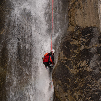
Critical Thermal Safety Factor: The combination of an extremely cold, glacier-fed water flow, high altitude, and low autumn air temperatures creates an aggressively cold environment. To prevent hypothermia, it is mandatory for team members to be equipped with heavy thermal wetsuits (up to 8mm neoprene) or specialized drysuits.
Expedition Progress and Technical Analysis of the Routes
Due to the complex nature of "Niko's Canyon," the operation was divided into three fundamental phases:
Phase 1: Portaging equipment from Becho village to the canyon's starting point (GPS: 43°07'49.4"N 42°35'57.3"E, 2360 m) and conducting aerial reconnaissance of the gorge using drones.
Phase 2: Partial descent of the gorge, installing anchor stations up to the most difficult section, and visual scouting of the lower part.
Phase 3: Complete and continuous descent of the canyon.
1. "Niko's Canyon"
The canyon is carved entirely out of solid granite rock. It does not feature deep water pools (which eliminates the need for frequent swimming), but it stands out due to its supreme technical difficulty and massive vertical drop.
Start Point: GPS: 43°07'49.4"N 42°35'57.3"E | Elevation: 2360 m above sea level.
Exit Point: GPS: 43°07'09.4"N 42°35'44.2"E | Elevation: 2070 m above sea level.
Vertical Parameters: The total vertical drop is 290 meters.
Route Architecture: Includes 12 waterfalls and requires 14 vertical descents (abseils/rappels).
Morphological Zones and Critical Section:
Upper Section: Relatively open and technically straightforward for orientation.
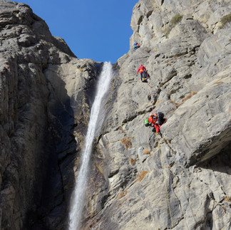
The 110-Meter Waterfall: The main technical challenge of the gorge. To mitigate the risks of heavy water flow, rockfalls, and icefalls, five independent anchor stations were installed along the vertical wall. Complex horizontal traverses were set up to transition between these stations, allowing the team to safely maneuver away from the main aquatic impact zone. The highest single vertical pitch from one station was 75 meters.
Lower (Confined and High-Volume) Section: After the 110-meter waterfall, Niko's Canyon merges with the main, highest-volume waterfall of Shdugra, forming a unified gorge. From this intersection, environmental conditions change dramatically and radically. Since two powerful hydrological flows unite here, the water volume (discharge) increases approximately fivefold (5x). This massive volume flows through a chaos of giant boulders (boulder choke), making movement and safety control exceptionally difficult. The gorge becomes strictly confined, enclosed by towering vertical walls reaching up to 200 meters. This factor, combined with the heavy hydraulic flow, creates an absolute Commitment Zone (complete technical isolation), as finding any alternative exit or emergency evacuation route from this section is impossible—the only way out is straight forward, to the very end of the canyon (Exit Point).
2. "Dali" Canyon
In parallel with Niko's Canyon, the expedition successfully executed the first descent of Dali Canyon. This route is characterized by a relatively compact, open, and technically less aggressive terrain.
Start Point: GPS: 43°07'18.2"N 42°35'14.1"E | Elevation: 2260 m above sea level.
Exit Point: GPS: 43°07'07.2"N 42°35'18.9"E | Elevation: 2125 m above sea level.
Vertical Parameters: The total vertical drop is 135 meters.
Route Architecture: Includes 5 waterfalls, the highest of which is 50 meters tall.
Specification: Formed in granite rock, the gorge is open (lacks enclosed/confined corridors) and has no deep water pools. Although it is technically more accessible, proper thermal protection remains mandatory due to the low temperatures.
Expedition Outcomes
This complex operation conducted by the Canyoneering Federation of Georgia in the Shdugra Valley in October 2025 will be written in golden letters in the adventure history of the region. Precise topographic planning, fixed GPS coordinates, innovative tactical decisions, and the strict management of thermal risks (utilizing 8mm wetsuits and drysuits) have proven that the Federation has the capability to execute world-class, highest-category expeditionary first descents while fully adhering to international safety standards.


Comments